


De Manosque à Castellane - étape 1 - Manosque - St Martin de Brômes

mrcat
User
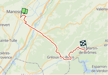

Length
22 km

Max alt
518 m

Uphill gradient
505 m
Km-Effort
29 km

Min alt
288 m

Downhill gradient
469 m
Boucle
No
Creation date :
2023-06-28 15:35:15.277
Updated on :
2023-06-29 10:37:45.73
5h24
Difficulty : Difficult

FREE GPS app for hiking
 SityTrail
IGN / Geographical institutes
SityTrail Plus
The world is yours!
About
Trail Walking of 22 km to be discovered at Provence-Alpes-Côte d'Azur, Alpes-de-Haute-Provence, Manosque. This trail is proposed by mrcat.
Positioning
Country:
France
Region :
Provence-Alpes-Côte d'Azur
Department/Province :
Alpes-de-Haute-Provence
Municipality :
Manosque
Location:
Unknown
Start:(Dec)
Start:(UTM)
724557 ; 4855997 (31T) N.
Comments