


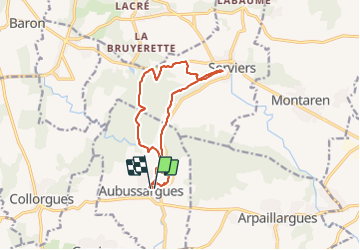
Aubussargue

rando30129
User

Length
13.5 km

Max alt
171 m

Uphill gradient
192 m
Km-Effort
16.1 km

Min alt
101 m

Downhill gradient
191 m
Boucle
Yes
Creation date :
2023-06-29 06:53:27.856
Updated on :
2023-06-29 10:39:16.479
3h45
Difficulty : Easy

FREE GPS app for hiking
 SityTrail
IGN / Geographical institutes
SityTrail Plus
The world is yours!
About
Trail Walking of 13.5 km to be discovered at Occitania, Gard, Aubussargues. This trail is proposed by rando30129.
Description
du plat et beaucoup d'ombre
Positioning
Country:
France
Region :
Occitania
Department/Province :
Gard
Municipality :
Aubussargues
Location:
Unknown
Start:(Dec)
Start:(UTM)
606594 ; 4873613 (31T) N.
Comments