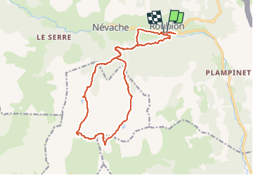
La Gardiole par les lacs Cristol et Oule

taguette
User

Length
19.9 km

Max alt
2740 m

Uphill gradient
1242 m
Km-Effort
36 km

Min alt
1580 m

Downhill gradient
1241 m
Boucle
Yes
Creation date :
2023-06-29 05:30:00.287
Updated on :
2023-06-29 12:00:49.226
6h26
Difficulty : Very difficult

FREE GPS app for hiking
 SityTrail
IGN / Geographical institutes
SityTrail Plus
The world is yours!
About
Trail Walking of 19.9 km to be discovered at Provence-Alpes-Côte d'Azur, Hautes-Alpes, Névache. This trail is proposed by taguette.
Positioning
Country:
France
Region :
Provence-Alpes-Côte d'Azur
Department/Province :
Hautes-Alpes
Municipality :
Névache
Location:
Unknown
Start:(Dec)
Start:(UTM)
313398 ; 4987546 (32T) N.
Comments