Trail Mountain bike Plan-d'Aups-Sainte-Baume - Au pied de la Sainte Baume - Photo
 kiteloop
kiteloop

User

© OpenStreetMap contributors
Length
Length
30 km
Max alt
Max alt
918 m
Uphill gradient
Uphill gradient
562 m
Km-Effort
Km-Effort  
37 km
Min alt
Min alt
610 m
Downhill gradient
Downhill gradient
570 m
Boucle
Boucle
Yes
Creation date :
2014-12-10 00:00:00.0
Updated on :
2014-12-10 00:00:00.0

(0 Reviews)

Mountain bike
Mountain bike
2h53
Difficulty : Unknown

Scan this QR Code to open this trail in the SityTrail application

FREE GPS app for hiking

Logo SityTrail SityTrail

IGN / Geographical institutes

Download SityTrail from the App Store Download SityTrail from Google Play

Logo SityTrail SityTrail World

The world is yours!

Download SityTrail from the App Store Download SityTrail from Google Play Download SityTrail on Huawei AppGallery

About

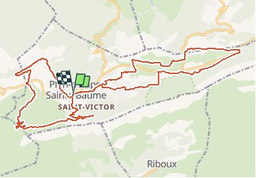
Trail Mountain bike of 30 km to be discovered at Provence-Alpes-Côte d'Azur, Var, Plan-d'Aups-Sainte-Baume. This trail is proposed by kiteloop.

Description

A part une cote de 350 metres bien raide, la randonnée ne presente aucune difficulté et offre de beaux single track en sous bois
la randonnée est un 8. de ce fait il n''y a pas de sens particulier, la deuxieme  boucle en direction de l''est est tres facile et peu se faire pour des vttistes sans expérience, et en famille.

Elevation profile

Points of interest

Point of interest Plan-d'Aups-Sainte-Baume - poi_402605 - Photo
kiteloop
PLAN-D'AUPS-SAINTE-BAUME 

Positioning

Country:
France
Region :
Provence-Alpes-Côte d'Azur
Department/Province :
Var
Municipality :
Plan-d'Aups-Sainte-Baume
Location:
Unknown
Start:(UTM)
719982 ; 4800696 (31T) N.

Trails nearby

Trail Walking Plan-d'Aups-Sainte-Baume - Sainte Baume 8,5 km - Photo
Walking
GUIDE
rvapeldo

Walking

Medium
(1)
Plan-d'Aups-Sainte-Baume, Provence-Alpes-Côte d'Azur, Var, France
8.4 km | 15.5 km-effort
4h 38min
Yes
Trail Walking Plan-d'Aups-Sainte-Baume - SityTrail - Sentier merveilleux - La Ste baume - Le Plan d'aups  - Photo
Walking
GUIDE
affinetataille

Walking

Medium
(1)
Plan-d'Aups-Sainte-Baume, Provence-Alpes-Côte d'Azur, Var, France
15 km | 23 km-effort
6h 0min
Yes
Trail Walking Gémenos - dent de roque forcade. cauvin.bertagne. 2 avril 2018 - Photo
Walking
marchev

Walking

Medium
(1)
Gémenos, Provence-Alpes-Côte d'Azur, Bouches-du-Rhône, France
12.7 km | 20 km-effort
4h 31min
Yes
Trail Walking Auriol - la crete des infernets - Photo
Walking
Coryphene

Walking

Difficult
(1)
Auriol, Provence-Alpes-Côte d'Azur, Bouches-du-Rhône, France
8.6 km | 14 km-effort
3h 22min
Yes
Trail Walking Plan-d'Aups-Sainte-Baume - Crêts de la Ste Baume - Photo
Walking
tracegps

Walking

Medium
(2)
Plan-d'Aups-Sainte-Baume, Provence-Alpes-Côte d'Azur, Var, France
15.4 km | 23 km-effort
5h 0min
Yes
Trail Walking Gémenos - Autour des Dents de Roque Forcade, Tour de Cauvin - Photo
Walking
tracegps

Walking

Difficult
(1)
Gémenos, Provence-Alpes-Côte d'Azur, Bouches-du-Rhône, France
7.6 km | 11.7 km-effort
3h 15min
Yes
Trail Walking Plan-d'Aups-Sainte-Baume - Du Col du Saint-Pilon au Pas de l'Aï, Sainte Baume - Photo
Walking
tracegps

Walking

Medium
(1)
Plan-d'Aups-Sainte-Baume, Provence-Alpes-Côte d'Azur, Var, France
13.1 km | 20 km-effort
5h 15min
Yes
Trail Walking Riboux - Riboux - Forêt de Malaucène - Photo
Walking
tracegps

Walking

Medium
(4)
Riboux, Provence-Alpes-Côte d'Azur, Var, France
12.2 km | 15.2 km-effort
2h 40min
Yes
Trail Walking Plan-d'Aups-Sainte-Baume - La Grotte aux oiseaux - Plan d'Aups  - Photo
Walking
tracegps

Walking

Medium
(1)
Plan-d'Aups-Sainte-Baume, Provence-Alpes-Côte d'Azur, Var, France
8.8 km | 12.5 km-effort
2h 30min
Yes


Close
My subscriptions