


Chaponost boucle

maclobar
User
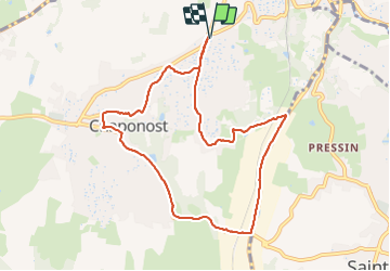

Length
9.2 km

Max alt
333 m

Uphill gradient
143 m
Km-Effort
11.2 km

Min alt
221 m

Downhill gradient
143 m
Boucle
Yes
Creation date :
2023-06-29 11:24:12.95
Updated on :
2023-06-30 00:34:11.723
1h56
Difficulty : Medium

FREE GPS app for hiking
 SityTrail
IGN / Geographical institutes
SityTrail Plus
The world is yours!
About
Trail Walking of 9.2 km to be discovered at Auvergne-Rhône-Alpes, Rhône, Chaponost. This trail is proposed by maclobar.
Description
a faire plutôt un dimanche car beaucoup de voitures
Photos


Positioning
Country:
France
Region :
Auvergne-Rhône-Alpes
Department/Province :
Rhône
Municipality :
Chaponost
Location:
Unknown
Start:(Dec)
Start:(UTM)
636960 ; 5064502 (31T) N.
Comments