


De Manosque à Castellane - jour 2 - Saint Martin de Bromes à Quinson

mrcat
User
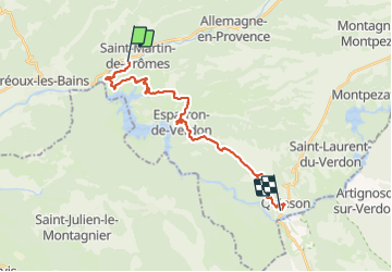

Length
22 km

Max alt
550 m

Uphill gradient
547 m
Km-Effort
29 km

Min alt
350 m

Downhill gradient
528 m
Boucle
No
Creation date :
2023-06-30 04:49:18.25
Updated on :
2023-06-30 13:10:52.984
6h07
Difficulty : Very difficult

FREE GPS app for hiking
 SityTrail
IGN / Geographical institutes
SityTrail Plus
The world is yours!
About
Trail Walking of 22 km to be discovered at Provence-Alpes-Côte d'Azur, Alpes-de-Haute-Provence, Saint-Martin-de-Brômes. This trail is proposed by mrcat.
Positioning
Country:
France
Region :
Provence-Alpes-Côte d'Azur
Department/Province :
Alpes-de-Haute-Provence
Municipality :
Saint-Martin-de-Brômes
Location:
Unknown
Start:(Dec)
Start:(UTM)
736653 ; 4850182 (31T) N.
Comments