Trail Mountain bike Malauzat - Le traversin - Photo
 Michel63
Michel63

User

© OpenStreetMap contributors
Length
Length
52 km
Max alt
Max alt
1093 m
Uphill gradient
Uphill gradient
1079 m
Km-Effort
Km-Effort  
66 km
Min alt
Min alt
389 m
Downhill gradient
Downhill gradient
1079 m
Boucle
Boucle
Yes
Creation date :
2023-06-30 15:39:12.789
Updated on :
2023-06-30 17:16:31.199

(0 Reviews)

Mountain bike
Mountain bike
4h35
Difficulty : Very difficult

Scan this QR Code to open this trail in the SityTrail application

FREE GPS app for hiking

Logo SityTrail SityTrail

IGN / Geographical institutes

Download SityTrail from the App Store Download SityTrail from Google Play

Logo SityTrail SityTrail World

The world is yours!

Download SityTrail from the App Store Download SityTrail from Google Play Download SityTrail on Huawei AppGallery

About

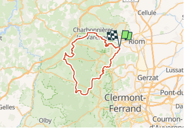
Trail Mountain bike of 52 km to be discovered at Auvergne-Rhône-Alpes, Puy-de-Dôme, Malauzat. This trail is proposed by Michel63.

Description

boucle au départ de Saint Genes l'enfant jusqu'au traversin entre Pariou et Puy-de-Dome

Elevation profile

Positioning

Country:
France
Region :
Auvergne-Rhône-Alpes
Department/Province :
Puy-de-Dôme
Municipality :
Malauzat
Location:
Unknown
Start:(UTM)
505261 ; 5081036 (31T) N.

Trails nearby

Trail On foot Loubeyrat - La Vallee des Prades - Photo
On foot
PRO

On foot

Easy
(1)
Loubeyrat, Auvergne-Rhône-Alpes, Puy-de-Dôme, France
11.1 km | 15.6 km-effort
3h 33min
Yes
Trail Walking Enval - Enval_Gorges - Photo
Walking
GUIDE
jagarnier

Walking

Medium
(1)
Enval, Auvergne-Rhône-Alpes, Puy-de-Dôme, France
9.1 km | 13.2 km-effort
2h 45min
Yes
Trail Walking Châtel-Guyon - Chazeron sans souci - Photo
Walking
Gegetop

Walking

Easy
(1)
Châtel-Guyon, Auvergne-Rhône-Alpes, Puy-de-Dôme, France
6.6 km | 9.7 km-effort
1h 45min
Yes
Trail Walking Châtel-Guyon - Boucle de Rochepradière en passant par Douhady - Photo
Walking
Gegetop

Walking

Easy
(1)
Châtel-Guyon, Auvergne-Rhône-Alpes, Puy-de-Dôme, France
6.7 km | 9.7 km-effort
2h 6min
Yes
Trail Walking Châtel-Guyon - Le tour de Montaclier - Saint Hippolyte - Photo
Walking
tracegps

Walking

Difficult
(1)
Châtel-Guyon, Auvergne-Rhône-Alpes, Puy-de-Dôme, France
14 km | 19.6 km-effort
3h 30min
Yes
Trail Mountain bike Volvic - Tour du Puy de Dôme en VTT - Photo
Mountain bike
tracegps

Mountain bike

Very difficult
(1)
Volvic, Auvergne-Rhône-Alpes, Puy-de-Dôme, France
62 km | 85 km-effort
5h 30min
Yes
Trail Walking Volvic - Les sources de Volvic - Photo
Walking
tracegps

Walking

Medium
(2)
Volvic, Auvergne-Rhône-Alpes, Puy-de-Dôme, France
10.9 km | 14.3 km-effort
3h 0min
Yes
Trail Walking Volvic - Egaules (près de Luzet) - Photo
Walking
tracegps

Walking

Difficult
(1)
Volvic, Auvergne-Rhône-Alpes, Puy-de-Dôme, France
8.8 km | 10.8 km-effort
2h 45min
Yes
Trail On foot Châtel-Guyon - La Vallée du Sans-Souci - Photo
On foot
PRO

On foot

Easy
Châtel-Guyon, Auvergne-Rhône-Alpes, Puy-de-Dôme, France
4.4 km | 6.5 km-effort
1h 28min
Yes


Close
My subscriptions