


Rando kayak Agay en direction du viaduc et retour

topolino
User
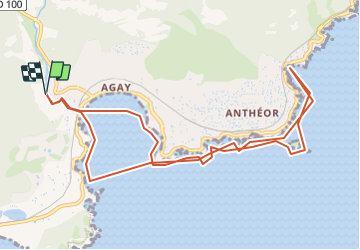

Length
11.9 km

Max alt
12 m

Uphill gradient
42 m
Km-Effort
12.4 km

Min alt
0 m

Downhill gradient
42 m
Boucle
Yes
Creation date :
2023-07-02 18:15:29.0
Updated on :
2023-07-02 18:15:29.847
2h00
Difficulty : Medium

FREE GPS app for hiking
 SityTrail
IGN / Geographical institutes
SityTrail Plus
The world is yours!
About
Trail Canoe - kayak of 11.9 km to be discovered at Provence-Alpes-Côte d'Azur, Var, Saint-Raphaël. This trail is proposed by topolino.
Positioning
Country:
France
Region :
Provence-Alpes-Côte d'Azur
Department/Province :
Var
Municipality :
Saint-Raphaël
Location:
Unknown
Start:(Dec)
Start:(UTM)
326098 ; 4811246 (32T) N.
Comments