


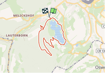
2023-07-03_16h41m52_Circuit_auto-pdestre_Echternach_Lac

mumu.larandonneuse
User GUIDE


2h15
Difficulty : Medium

FREE GPS app for hiking
 SityTrail
IGN / Geographical institutes
SityTrail Plus
The world is yours!
About
Trail Walking of 7.1 km to be discovered at Unknown, Canton Echternach, Echternach. This trail is proposed by mumu.larandonneuse.
Description
Le sentier prend son départ au lac d'Echternach. Il commence par une ascension exigeante à travers la forêt et après environ 2,5 km, le point le plus élevé de la randonnée est atteint sur 350 m. Vous pourriez ensuite vous reposer sur des bancs.
La deuxième partie de la randonnée redescend ensuite jusqu'au lac que vous contournez à moitié pour revenir à votre point de départ.
ℹ️ visitmullerthal.lu
Positioning
Comments