


plan d eau marville/flassigny

veroberton
User
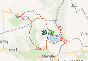

Length
10.6 km

Max alt
315 m

Uphill gradient
232 m
Km-Effort
13.7 km

Min alt
197 m

Downhill gradient
232 m
Boucle
Yes
Creation date :
2023-07-03 12:37:43.942
Updated on :
2023-07-03 18:54:44.256
3h15
Difficulty : Easy

FREE GPS app for hiking
 SityTrail
IGN / Geographical institutes
SityTrail Plus
The world is yours!
About
Trail Walking of 10.6 km to be discovered at Grand Est, Meuse, Marville. This trail is proposed by veroberton.
Positioning
Country:
France
Region :
Grand Est
Department/Province :
Meuse
Municipality :
Marville
Location:
Unknown
Start:(Dec)
Start:(UTM)
678161 ; 5481843 (31U) N.
Comments