


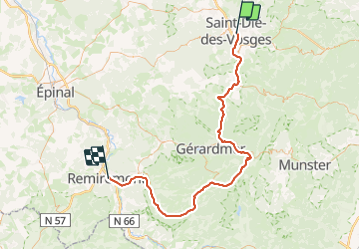
Saint Dié - Remiremont via La Bresse et Cornimont

claudel
User

Length
84 km

Max alt
969 m

Uphill gradient
1309 m
Km-Effort
102 km

Min alt
342 m

Downhill gradient
1266 m
Boucle
No
Creation date :
2023-07-04 13:06:31.301
Updated on :
2023-07-04 13:08:18.422
6h09
Difficulty : Very difficult

FREE GPS app for hiking
 SityTrail
IGN / Geographical institutes
SityTrail Plus
The world is yours!
About
Trail Road bike of 84 km to be discovered at Grand Est, Vosges, Saint-Dié-des-Vosges. This trail is proposed by claudel.
Positioning
Country:
France
Region :
Grand Est
Department/Province :
Vosges
Municipality :
Saint-Dié-des-Vosges
Location:
Unknown
Start:(Dec)
Start:(UTM)
347771 ; 5349739 (32U) N.
Comments