


J12.lac d oule bareges

viaul
User GUIDE
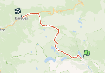

Length
24 km

Max alt
2511 m

Uphill gradient
928 m
Km-Effort
38 km

Min alt
1227 m

Downhill gradient
1518 m
Boucle
No
Creation date :
2023-07-03 16:14:55.0
Updated on :
2023-07-04 16:07:16.373
9h30
Difficulty : Very difficult

FREE GPS app for hiking
 SityTrail
IGN / Geographical institutes
SityTrail Plus
The world is yours!
About
Trail Walking of 24 km to be discovered at Occitania, Hautespyrenees, Aragnouet. This trail is proposed by viaul.
Positioning
Country:
France
Region :
Occitania
Department/Province :
Hautespyrenees
Municipality :
Aragnouet
Location:
Unknown
Start:(Dec)
Start:(UTM)
271727 ; 4745102 (31T) N.
Comments