


AGAY PARC DE L ESTEREL

topolino
User
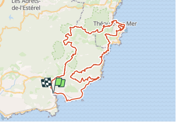

Length
51 km

Max alt
370 m

Uphill gradient
1327 m
Km-Effort
69 km

Min alt
0 m

Downhill gradient
1322 m
Boucle
Yes
Creation date :
2023-07-04 17:21:33.193
Updated on :
2023-07-04 17:22:12.346
4h45
Difficulty : Very difficult

FREE GPS app for hiking
 SityTrail
IGN / Geographical institutes
SityTrail Plus
The world is yours!
About
Trail Mountain bike of 51 km to be discovered at Provence-Alpes-Côte d'Azur, Var, Saint-Raphaël. This trail is proposed by topolino.
Positioning
Country:
France
Region :
Provence-Alpes-Côte d'Azur
Department/Province :
Var
Municipality :
Saint-Raphaël
Location:
Unknown
Start:(Dec)
Start:(UTM)
326225 ; 4811268 (32T) N.
Comments