


Col de Colombart

Nuance
User
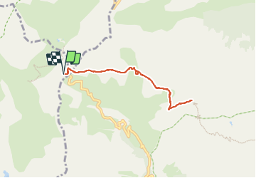

Length
7 km

Max alt
2540 m

Uphill gradient
231 m
Km-Effort
10.1 km

Min alt
2430 m

Downhill gradient
228 m
Boucle
Yes
Creation date :
2023-07-04 09:17:20.0
Updated on :
2023-07-04 18:03:54.57
2h17
Difficulty : Medium

FREE GPS app for hiking
 SityTrail
IGN / Geographical institutes
SityTrail Plus
The world is yours!
About
Trail Walking of 7 km to be discovered at Provence-Alpes-Côte d'Azur, Alpes-de-Haute-Provence, Uvernet-Fours. This trail is proposed by Nuance.
Positioning
Country:
France
Region :
Provence-Alpes-Côte d'Azur
Department/Province :
Alpes-de-Haute-Provence
Municipality :
Uvernet-Fours
Location:
Unknown
Start:(Dec)
Start:(UTM)
324208 ; 4909263 (32T) N.
Comments