


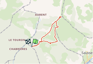
TÊTE DE TRAVERS

nordan
User

Length
12.9 km

Max alt
2150 m

Uphill gradient
1007 m
Km-Effort
26 km

Min alt
1315 m

Downhill gradient
1003 m
Boucle
Yes
Creation date :
2023-07-05 08:04:57.286
Updated on :
2023-07-05 14:07:10.073
4h31
Difficulty : Difficult

FREE GPS app for hiking
 SityTrail
IGN / Geographical institutes
SityTrail Plus
The world is yours!
About
Trail Walking of 12.9 km to be discovered at Provence-Alpes-Côte d'Azur, Alpes-de-Haute-Provence, Castellet-lès-Sausses. This trail is proposed by nordan.
Positioning
Country:
France
Region :
Provence-Alpes-Côte d'Azur
Department/Province :
Alpes-de-Haute-Provence
Municipality :
Castellet-lès-Sausses
Location:
Unknown
Start:(Dec)
Start:(UTM)
316177 ; 4875928 (32T) N.
Comments