


la cassiere

Papou63patrick
User
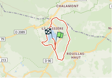

Length
6.7 km

Max alt
997 m

Uphill gradient
161 m
Km-Effort
8.8 km

Min alt
865 m

Downhill gradient
161 m
Boucle
Yes
Creation date :
2023-06-29 16:31:28.057
Updated on :
2023-07-05 16:36:11.607
1h37
Difficulty : Very easy

FREE GPS app for hiking
 SityTrail
IGN / Geographical institutes
SityTrail Plus
The world is yours!
About
Trail Walking of 6.7 km to be discovered at Auvergne-Rhône-Alpes, Puy-de-Dôme, Aydat. This trail is proposed by Papou63patrick.
Positioning
Country:
France
Region :
Auvergne-Rhône-Alpes
Department/Province :
Puy-de-Dôme
Municipality :
Aydat
Location:
Unknown
Start:(Dec)
Start:(UTM)
499934 ; 5059070 (31T) N.
Comments