


LE VERNET . COL DU MAL D HIVER . COL DU LABOURET . O L M

RobinMicheline
User GUIDE
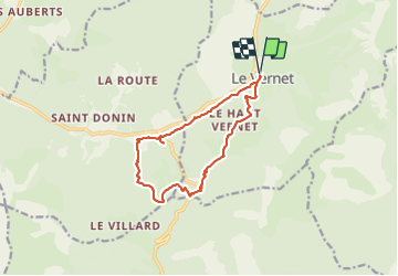

Length
13 km

Max alt
1327 m

Uphill gradient
330 m
Km-Effort
17.4 km

Min alt
1135 m

Downhill gradient
331 m
Boucle
Yes
Creation date :
2023-07-06 03:41:15.199
Updated on :
2023-07-07 11:58:23.737
3h17
Difficulty : Medium

FREE GPS app for hiking
 SityTrail
IGN / Geographical institutes
SityTrail Plus
The world is yours!
About
Trail Walking of 13 km to be discovered at Provence-Alpes-Côte d'Azur, Alpes-de-Haute-Provence, Le Vernet. This trail is proposed by RobinMicheline.
Description
Ne pas faire s il a plu . Agréable
Photos


Positioning
Country:
France
Region :
Provence-Alpes-Côte d'Azur
Department/Province :
Alpes-de-Haute-Provence
Municipality :
Le Vernet
Location:
Unknown
Start:(Dec)
Start:(UTM)
291791 ; 4905897 (32T) N.
Comments