


CV Col de Holdereck 06-07-2023

maureengeorges
User
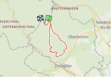

Length
10.5 km

Max alt
475 m

Uphill gradient
354 m
Km-Effort
15.2 km

Min alt
280 m

Downhill gradient
352 m
Boucle
Yes
Creation date :
2023-07-06 06:59:02.55
Updated on :
2023-07-06 10:03:44.769
3h04
Difficulty : Difficult

FREE GPS app for hiking
 SityTrail
IGN / Geographical institutes
SityTrail Plus
The world is yours!
About
Trail Walking of 10.5 km to be discovered at Grand Est, Bas-Rhin, Oberbronn. This trail is proposed by maureengeorges.
Positioning
Country:
France
Region :
Grand Est
Department/Province :
Bas-Rhin
Municipality :
Oberbronn
Location:
Unknown
Start:(Dec)
Start:(UTM)
395376 ; 5422959 (32U) N.
Comments