


mont Cessey par les Fourneaux

dcharbonnier
User
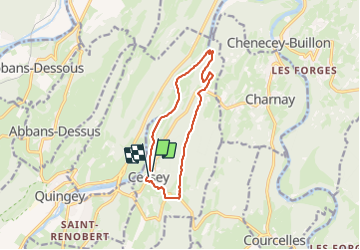

Length
10.6 km

Max alt
541 m

Uphill gradient
338 m
Km-Effort
15 km

Min alt
266 m

Downhill gradient
331 m
Boucle
Yes
Creation date :
2023-07-06 12:11:01.178
Updated on :
2023-07-06 15:34:56.157
3h22
Difficulty : Medium

FREE GPS app for hiking
 SityTrail
IGN / Geographical institutes
SityTrail Plus
The world is yours!
About
Trail Walking of 10.6 km to be discovered at Bourgogne-Franche-Comté, Doubs, Cessey. This trail is proposed by dcharbonnier.
Positioning
Country:
France
Region :
Bourgogne-Franche-Comté
Department/Province :
Doubs
Municipality :
Cessey
Location:
Unknown
Start:(Dec)
Start:(UTM)
721162 ; 5221474 (31T) N.
Comments