


Mauléon Soste fait

almitpau
User
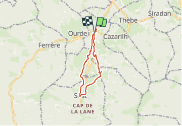

Length
10.3 km

Max alt
801 m

Uphill gradient
296 m
Km-Effort
14.3 km

Min alt
566 m

Downhill gradient
301 m
Boucle
Yes
Creation date :
2023-07-07 07:43:29.0
Updated on :
2023-07-07 13:48:16.295
6h03
Difficulty : Difficult

FREE GPS app for hiking
 SityTrail
IGN / Geographical institutes
SityTrail Plus
The world is yours!
About
Trail Walking of 10.3 km to be discovered at Occitania, Hautespyrenees, Mauléon-Barousse. This trail is proposed by almitpau.
Positioning
Country:
France
Region :
Occitania
Department/Province :
Hautespyrenees
Municipality :
Mauléon-Barousse
Location:
Unknown
Start:(Dec)
Start:(UTM)
301587 ; 4759132 (31T) N.
Comments