


Madone d'Utelle

LEDUNC
User
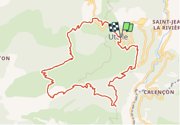

Length
13.9 km

Max alt
1188 m

Uphill gradient
811 m
Km-Effort
25 km

Min alt
420 m

Downhill gradient
814 m
Boucle
Yes
Creation date :
2023-07-07 06:42:22.53
Updated on :
2023-09-04 10:49:03.53
4h42
Difficulty : Very difficult

FREE GPS app for hiking
 SityTrail
IGN / Geographical institutes
SityTrail Plus
The world is yours!
About
Trail Walking of 13.9 km to be discovered at Provence-Alpes-Côte d'Azur, Maritime Alps, Utelle. This trail is proposed by LEDUNC.
Description
Parking d'Utelle, départ vers la chapelle Saint Antoine, continuer vers la Madone d'Utelle, sanctuaire, table d'orientation, retour Utelle.
Positioning
Country:
France
Region :
Provence-Alpes-Côte d'Azur
Department/Province :
Maritime Alps
Municipality :
Utelle
Location:
Unknown
Start:(Dec)
Start:(UTM)
359390 ; 4864098 (32T) N.
Comments