


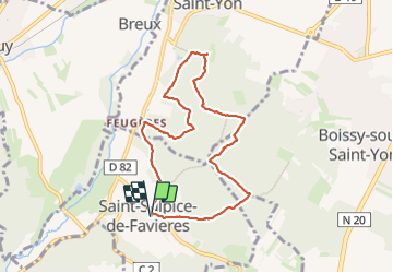
Saint-Sulpice-de-Favières

guydu41
User


1h55
Difficulty : Medium

FREE GPS app for hiking
 SityTrail
IGN / Geographical institutes
SityTrail Plus
The world is yours!
About
Trail Walking of 7.5 km to be discovered at Ile-de-France, Essonne, Saint-Sulpice-de-Favières. This trail is proposed by guydu41.
Description
Petit circuit au départ du parking à côté de la très belle église de Saint-Sulpice-de-Favières.
Ce parcours n'emprunte que des chemins et sentiers dans le Bois de Baville et monte jusqu'à la Porte des Bourdeaux et l'église de Saint-Yon.
Photos


Positioning
Comments