


00 Camp 2023 - tour de chauffe

norbertmarteau
User
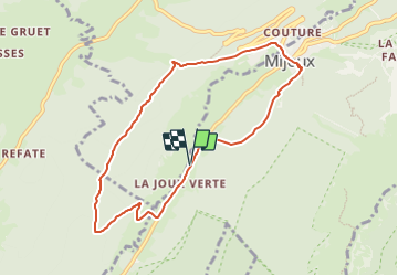

Length
8.2 km

Max alt
1210 m

Uphill gradient
392 m
Km-Effort
13.5 km

Min alt
945 m

Downhill gradient
391 m
Boucle
Yes
Creation date :
2023-07-07 22:38:27.943
Updated on :
2023-08-02 21:07:09.42
3h03
Difficulty : Difficult

FREE GPS app for hiking
 SityTrail
IGN / Geographical institutes
SityTrail Plus
The world is yours!
About
Trail Walking of 8.2 km to be discovered at Auvergne-Rhône-Alpes, Ain, Mijoux. This trail is proposed by norbertmarteau.
Positioning
Country:
France
Region :
Auvergne-Rhône-Alpes
Department/Province :
Ain
Municipality :
Mijoux
Location:
Unknown
Start:(Dec)
Start:(UTM)
729321 ; 5137817 (31T) N.
Comments