


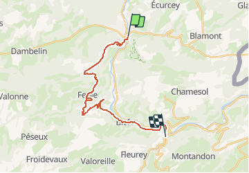
F.PontDeRoide-StHippolyte21km698m+Ped

francois58
User

Length
21 km

Max alt
772 m

Uphill gradient
688 m
Km-Effort
30 km

Min alt
346 m

Downhill gradient
665 m
Boucle
No
Creation date :
2014-12-10 00:00:00.0
Updated on :
2014-12-10 00:00:00.0
6h24
Difficulty : Easy

FREE GPS app for hiking
 SityTrail
IGN / Geographical institutes
SityTrail Plus
The world is yours!
About
Trail Walking of 21 km to be discovered at Bourgogne-Franche-Comté, Doubs, Pont-de-Roide-Vermondans. This trail is proposed by francois58.
Description
Randonnée en boucle de 5 jours - étape 2 de 5 : Pont de Roide - St Hippolyte - 14/05/2010
Positioning
Country:
France
Region :
Bourgogne-Franche-Comté
Department/Province :
Doubs
Municipality :
Pont-de-Roide-Vermondans
Location:
Unknown
Start:(Dec)
Start:(UTM)
331961 ; 5250295 (32T) N.
Comments