


Source du Lez du 07-07-2023

VANDERPUTTENMi
User GUIDE
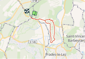

Length
6 km

Max alt
91 m

Uphill gradient
56 m
Km-Effort
6.8 km

Min alt
60 m

Downhill gradient
52 m
Boucle
Yes
Creation date :
2023-07-08 06:32:30.32
Updated on :
2023-07-15 17:44:44.259
1h32
Difficulty : Medium

FREE GPS app for hiking
 SityTrail
IGN / Geographical institutes
SityTrail Plus
The world is yours!
About
Trail Walking of 6 km to be discovered at Occitania, Hérault, Saint-Clément-de-Rivière. This trail is proposed by VANDERPUTTENMi.
Photos

Positioning
Country:
France
Region :
Occitania
Department/Province :
Hérault
Municipality :
Saint-Clément-de-Rivière
Location:
Unknown
Start:(Dec)
Start:(UTM)
568050 ; 4840772 (31T) N.
Comments