


Lyon

nicolasdresse
User

Length
12.1 km

Max alt
187 m

Uphill gradient
152 m
Km-Effort
14.2 km

Min alt
163 m

Downhill gradient
159 m
Boucle
No
Creation date :
2023-07-09 08:01:59.0
Updated on :
2023-07-09 11:03:15.462
3h00
Difficulty : Difficult

FREE GPS app for hiking
 SityTrail
IGN / Geographical institutes
SityTrail Plus
The world is yours!
About
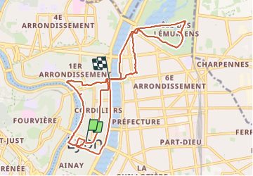
Trail Walking of 12.1 km to be discovered at Auvergne-Rhône-Alpes, Métropole de Lyon, Lyon. This trail is proposed by nicolasdresse.
Photos


Positioning
Country:
France
Region :
Auvergne-Rhône-Alpes
Department/Province :
Métropole de Lyon
Municipality :
Lyon
Location:
Lyon 2e Arrondissement
Start:(Dec)
Start:(UTM)
642504 ; 5068789 (31T) N.
Comments