


00 Camp 2023 - Champfromier

norbertmarteau
User
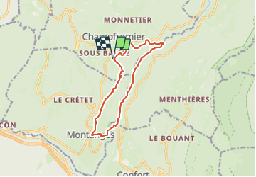

Length
12.1 km

Max alt
689 m

Uphill gradient
418 m
Km-Effort
17.7 km

Min alt
462 m

Downhill gradient
419 m
Boucle
Yes
Creation date :
2023-07-09 18:32:55.646
Updated on :
2023-07-09 18:33:42.717
4h00
Difficulty : Difficult

FREE GPS app for hiking
 SityTrail
IGN / Geographical institutes
SityTrail Plus
The world is yours!
About
Trail Walking of 12.1 km to be discovered at Auvergne-Rhône-Alpes, Ain, Champfromier. This trail is proposed by norbertmarteau.
Positioning
Country:
France
Region :
Auvergne-Rhône-Alpes
Department/Province :
Ain
Municipality :
Champfromier
Location:
Unknown
Start:(Dec)
Start:(UTM)
717052 ; 5118901 (31T) N.
Comments