


carrelet

chuck
User
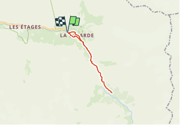

Length
9.7 km

Max alt
1915 m

Uphill gradient
280 m
Km-Effort
13.4 km

Min alt
1682 m

Downhill gradient
279 m
Boucle
Yes
Creation date :
2023-07-10 09:03:24.358
Updated on :
2023-07-10 13:09:19.249
3h17
Difficulty : Difficult

FREE GPS app for hiking
 SityTrail
IGN / Geographical institutes
SityTrail Plus
The world is yours!
About
Trail Walking of 9.7 km to be discovered at Auvergne-Rhône-Alpes, Isère, Saint-Christophe-en-Oisans. This trail is proposed by chuck.
Positioning
Country:
France
Region :
Auvergne-Rhône-Alpes
Department/Province :
Isère
Municipality :
Saint-Christophe-en-Oisans
Location:
Unknown
Start:(Dec)
Start:(UTM)
285847 ; 4979206 (32T) N.
Comments