


Robion - Rochers de Baude

kephas
User
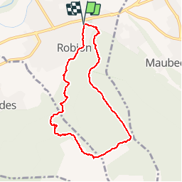

Length
8.4 km

Max alt
509 m

Uphill gradient
438 m
Km-Effort
14.2 km

Min alt
126 m

Downhill gradient
438 m
Boucle
Yes
Creation date :
2014-12-28 00:00:00.0
Updated on :
2014-12-28 00:00:00.0
3h01
Difficulty : Medium

FREE GPS app for hiking
 SityTrail
IGN / Geographical institutes
SityTrail Plus
The world is yours!
About
Trail Walking of 8.4 km to be discovered at Provence-Alpes-Côte d'Azur, Vaucluse, Robion. This trail is proposed by kephas.
Positioning
Country:
France
Region :
Provence-Alpes-Côte d'Azur
Department/Province :
Vaucluse
Municipality :
Robion
Location:
Unknown
Start:(Dec)
Start:(UTM)
669979 ; 4857187 (31T) N.
Comments