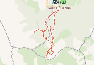
La Cascade Sainte-Catherine et la Cabane des Pierres

frizou83
User

Length
9 km

Max alt
1845 m

Uphill gradient
748 m
Km-Effort
19 km

Min alt
1131 m

Downhill gradient
748 m
Boucle
Yes
Creation date :
2023-07-10 17:14:25.645
Updated on :
2024-07-25 20:49:34.83
4h19
Difficulty : Very difficult

FREE GPS app for hiking
 SityTrail
IGN / Geographical institutes
SityTrail Plus
The world is yours!
About
Trail Walking of 9 km to be discovered at Provence-Alpes-Côte d'Azur, Hautes-Alpes, Poligny. This trail is proposed by frizou83.
Description
Ajouter 2,8 km pour l'AR au col de Chétive
Positioning
Country:
France
Region :
Provence-Alpes-Côte d'Azur
Department/Province :
Hautes-Alpes
Municipality :
Poligny
Location:
Unknown
Start:(Dec)
Start:(UTM)
263900 ; 4952145 (32T) N.
Comments