


Lac Negre

GOHIER
User

Length
26 km

Max alt
2618 m

Uphill gradient
1326 m
Km-Effort
45 km

Min alt
1035 m

Downhill gradient
1967 m
Boucle
No
Creation date :
2023-07-10 06:08:50.0
Updated on :
2023-07-10 18:17:25.956
4h37
Difficulty : Medium

FREE GPS app for hiking
 SityTrail
IGN / Geographical institutes
SityTrail Plus
The world is yours!
About
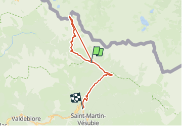
Trail Walking of 26 km to be discovered at Provence-Alpes-Côte d'Azur, Maritime Alps, Saint-Martin-Vésubie. This trail is proposed by GOHIER.
Description
Depuis le Boreon
Positioning
Country:
France
Region :
Provence-Alpes-Côte d'Azur
Department/Province :
Maritime Alps
Municipality :
Saint-Martin-Vésubie
Location:
Unknown
Start:(Dec)
Start:(UTM)
360868 ; 4887321 (32T) N.
Comments