


col joux plane

soso34
User
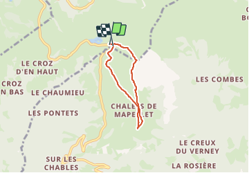

Length
4.2 km

Max alt
1861 m

Uphill gradient
191 m
Km-Effort
6.8 km

Min alt
1691 m

Downhill gradient
188 m
Boucle
Yes
Creation date :
2023-07-11 08:08:20.284
Updated on :
2023-07-11 09:57:26.639
1h48
Difficulty : Medium

FREE GPS app for hiking
 SityTrail
IGN / Geographical institutes
SityTrail Plus
The world is yours!
About
Trail Walking of 4.2 km to be discovered at Auvergne-Rhône-Alpes, Upper Savoy, Verchaix. This trail is proposed by soso34.
Positioning
Country:
France
Region :
Auvergne-Rhône-Alpes
Department/Province :
Upper Savoy
Municipality :
Verchaix
Location:
Unknown
Start:(Dec)
Start:(UTM)
323349 ; 5110991 (32T) N.
Comments