


Saint Lothain

fdm1
User
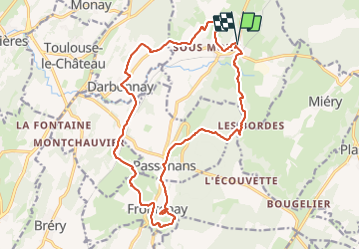

Length
19.6 km

Max alt
478 m

Uphill gradient
474 m
Km-Effort
26 km

Min alt
249 m

Downhill gradient
478 m
Boucle
Yes
Creation date :
2023-07-11 06:48:33.215
Updated on :
2023-07-11 12:25:38.322
5h33
Difficulty : Easy

FREE GPS app for hiking
 SityTrail
IGN / Geographical institutes
SityTrail Plus
The world is yours!
About
Trail Walking of 19.6 km to be discovered at Bourgogne-Franche-Comté, Jura, Saint-Lothain. This trail is proposed by fdm1.
Photos


Positioning
Country:
France
Region :
Bourgogne-Franche-Comté
Department/Province :
Jura
Municipality :
Saint-Lothain
Location:
Unknown
Start:(Dec)
Start:(UTM)
701646 ; 5189204 (31T) N.
Comments