


2023-07-11_18h11m12_C16

LUTZMarc
User
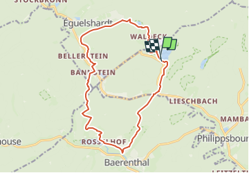

Length
14.9 km

Max alt
306 m

Uphill gradient
389 m
Km-Effort
20 km

Min alt
207 m

Downhill gradient
388 m
Boucle
Yes
Creation date :
2023-07-11 16:11:12.451
Updated on :
2024-11-01 09:18:00.513
4h34
Difficulty : Medium

FREE GPS app for hiking
 SityTrail
IGN / Geographical institutes
SityTrail Plus
The world is yours!
About
Trail Walking of 14.9 km to be discovered at Grand Est, Moselle, Philippsbourg. This trail is proposed by LUTZMarc.
Positioning
Country:
France
Region :
Grand Est
Department/Province :
Moselle
Municipality :
Philippsbourg
Location:
Unknown
Start:(Dec)
Start:(UTM)
392849 ; 5429506 (32U) N.
Comments