


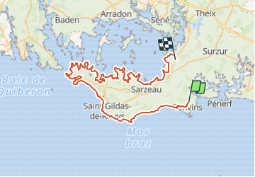
DE PENVINS A ST ARMEL PAR LE GR34

rousseau.mich
User

Length
77 km

Max alt
26 m

Uphill gradient
580 m
Km-Effort
84 km

Min alt
-5 m

Downhill gradient
592 m
Boucle
No
Creation date :
2023-07-12 19:28:38.751
Updated on :
2024-07-16 09:12:52.346
19h11
Difficulty : Very difficult
18h00
Difficulty : Medium

FREE GPS app for hiking
 SityTrail
IGN / Geographical institutes
SityTrail Plus
The world is yours!
About
Trail Walking of 77 km to be discovered at Brittany, Morbihan, Sarzeau. This trail is proposed by rousseau.mich.
Description
TOUR DE LA PRESQU4ILE DE RHUYS
Positioning
Country:
France
Region :
Brittany
Department/Province :
Morbihan
Municipality :
Sarzeau
Location:
Unknown
Start:(Dec)
Start:(UTM)
523904 ; 5261981 (30T) N.
Comments