


16092014

Mullender
User
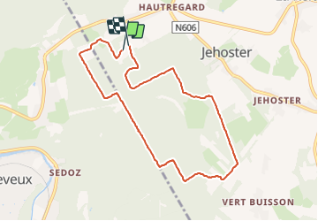

Length
7.7 km

Max alt
419 m

Uphill gradient
112 m
Km-Effort
9.3 km

Min alt
355 m

Downhill gradient
122 m
Boucle
Yes
Creation date :
2014-12-29 00:00:00.0
Updated on :
2014-12-29 00:00:00.0
1h37
Difficulty : Unknown

FREE GPS app for hiking
 SityTrail
IGN / Geographical institutes
SityTrail Plus
The world is yours!
About
Trail Other activity of 7.7 km to be discovered at Wallonia, Liège, Theux. This trail is proposed by Mullender.
Positioning
Country:
Belgium
Region :
Wallonia
Department/Province :
Liège
Municipality :
Theux
Location:
La Reid
Start:(Dec)
Start:(UTM)
695563 ; 5595924 (31U) N.
Comments