


Lacs de Millefonds

GOHIER
User
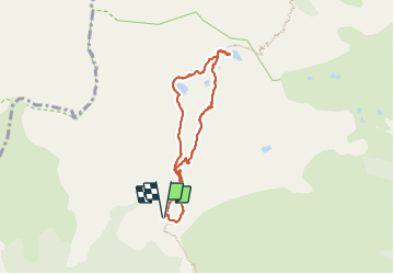

Length
6.8 km

Max alt
2395 m

Uphill gradient
390 m
Km-Effort
12 km

Min alt
2026 m

Downhill gradient
383 m
Boucle
Yes
Creation date :
2023-07-11 08:54:31.0
Updated on :
2023-07-13 07:33:09.208
3h49
Difficulty : Medium

FREE GPS app for hiking
 SityTrail
IGN / Geographical institutes
SityTrail Plus
The world is yours!
About
Trail Walking of 6.8 km to be discovered at Provence-Alpes-Côte d'Azur, Maritime Alps, Valdeblore. This trail is proposed by GOHIER.
Description
Prairies
Positioning
Country:
France
Region :
Provence-Alpes-Côte d'Azur
Department/Province :
Maritime Alps
Municipality :
Valdeblore
Location:
Unknown
Start:(Dec)
Start:(UTM)
354850 ; 4884416 (32T) N.
Comments