


Campels

mrcat
User
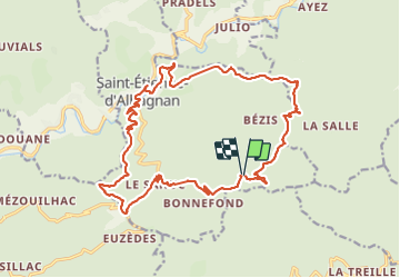

Length
23 km

Max alt
602 m

Uphill gradient
737 m
Km-Effort
33 km

Min alt
213 m

Downhill gradient
742 m
Boucle
Yes
Creation date :
2023-07-13 05:50:07.424
Updated on :
2023-07-13 12:47:23.44
5h51
Difficulty : Very difficult

FREE GPS app for hiking
 SityTrail
IGN / Geographical institutes
SityTrail Plus
The world is yours!
About
Trail Walking of 23 km to be discovered at Occitania, Hérault, Saint-Étienne-d'Albagnan. This trail is proposed by mrcat.
Positioning
Country:
France
Region :
Occitania
Department/Province :
Hérault
Municipality :
Saint-Étienne-d'Albagnan
Location:
Unknown
Start:(Dec)
Start:(UTM)
490904 ; 4817819 (31T) N.
Comments