


rando Veysonnaz Suisse

gerard28dupitaval
User
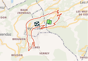

Length
9.8 km

Max alt
1399 m

Uphill gradient
409 m
Km-Effort
15.3 km

Min alt
1068 m

Downhill gradient
420 m
Boucle
No
Creation date :
2023-07-13 09:49:44.106
Updated on :
2023-07-13 14:02:16.06
4h12
Difficulty : Difficult

FREE GPS app for hiking
 SityTrail
IGN / Geographical institutes
SityTrail Plus
The world is yours!
About
Trail Walking of 9.8 km to be discovered at Valais/Wallis, Sion, Veysonnaz. This trail is proposed by gerard28dupitaval.
Description
rando famille
Positioning
Country:
Switzerland
Region :
Valais/Wallis
Department/Province :
Sion
Municipality :
Veysonnaz
Location:
Unknown
Start:(Dec)
Start:(UTM)
372269 ; 5117140 (32T) N.
Comments