


Larochette-Graulinster

edevuyst
User
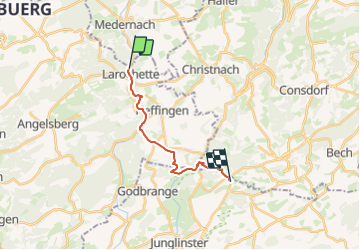

Length
11.8 km

Max alt
394 m

Uphill gradient
323 m
Km-Effort
15.8 km

Min alt
268 m

Downhill gradient
238 m
Boucle
No
Creation date :
2023-07-13 14:02:54.951
Updated on :
2023-07-13 14:03:14.501
3h35
Difficulty : Difficult

FREE GPS app for hiking
 SityTrail
IGN / Geographical institutes
SityTrail Plus
The world is yours!
About
Trail Walking of 11.8 km to be discovered at Unknown, Canton Mersch, Larochette. This trail is proposed by edevuyst.
Positioning
Country:
Luxembourg
Region :
Unknown
Department/Province :
Canton Mersch
Municipality :
Larochette
Location:
Unknown
Start:(Dec)
Start:(UTM)
299773 ; 5518918 (32U) N.
Comments