


aire de cote

ARVIEU
User
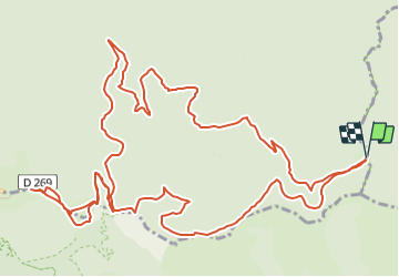

Length
18.4 km

Max alt
1556 m

Uphill gradient
685 m
Km-Effort
28 km

Min alt
997 m

Downhill gradient
685 m
Boucle
Yes
Creation date :
2023-07-13 15:53:39.729
Updated on :
2023-07-13 15:54:45.252
6h00
Difficulty : Difficult

FREE GPS app for hiking
 SityTrail
IGN / Geographical institutes
SityTrail Plus
The world is yours!
About
Trail Walking of 18.4 km to be discovered at Occitania, Lozère, Bassurels. This trail is proposed by ARVIEU.
Positioning
Country:
France
Region :
Occitania
Department/Province :
Lozère
Municipality :
Bassurels
Location:
Unknown
Start:(Dec)
Start:(UTM)
550719 ; 4885975 (31T) N.
Comments