


Lelex jura

papajp
User
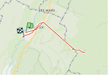

Length
7.2 km

Max alt
1493 m

Uphill gradient
638 m
Km-Effort
15.8 km

Min alt
850 m

Downhill gradient
644 m
Boucle
No
Creation date :
2023-07-14 11:53:08.0
Updated on :
2023-07-14 13:52:59.154
1h59
Difficulty : Difficult

FREE GPS app for hiking
 SityTrail
IGN / Geographical institutes
SityTrail Plus
The world is yours!
About
Trail Walking of 7.2 km to be discovered at Auvergne-Rhône-Alpes, Ain, Lélex. This trail is proposed by papajp.
Positioning
Country:
France
Region :
Auvergne-Rhône-Alpes
Department/Province :
Ain
Municipality :
Lélex
Location:
Unknown
Start:(Dec)
Start:(UTM)
725922 ; 5131615 (31T) N.
Comments