


Château Thierry Rando de nuit du 14-07-2023

VANDERPUTTENMi
User GUIDE
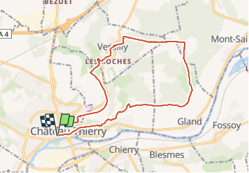

Length
16.8 km

Max alt
226 m

Uphill gradient
301 m
Km-Effort
21 km

Min alt
58 m

Downhill gradient
302 m
Boucle
Yes
Creation date :
2023-07-14 17:04:39.964
Updated on :
2023-07-15 17:25:53.45
4h23
Difficulty : Very difficult

FREE GPS app for hiking
 SityTrail
IGN / Geographical institutes
SityTrail Plus
The world is yours!
About
Trail Walking of 16.8 km to be discovered at Hauts-de-France, Aisne, Château-Thierry. This trail is proposed by VANDERPUTTENMi.
Photos

Positioning
Country:
France
Region :
Hauts-de-France
Department/Province :
Aisne
Municipality :
Château-Thierry
Location:
Unknown
Start:(Dec)
Start:(UTM)
529055 ; 5432437 (31U) N.
Comments