


Vas 2023 - Etape 2 - Villeneuve sur Ainse / Neuville Day

norbertmarteau
User
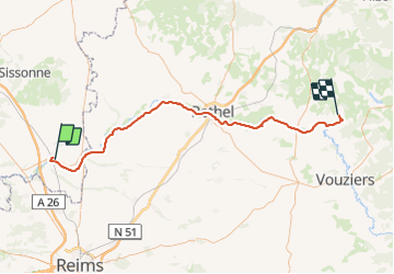

Length
70 km

Max alt
151 m

Uphill gradient
527 m
Km-Effort
76 km

Min alt
54 m

Downhill gradient
441 m
Boucle
No
Creation date :
2023-07-15 08:41:57.196
Updated on :
2023-07-15 10:00:06.0
5h17
Difficulty : Very difficult

FREE GPS app for hiking
 SityTrail
IGN / Geographical institutes
SityTrail Plus
The world is yours!
About
Trail Mountain bike of 70 km to be discovered at Hauts-de-France, Aisne, Villeneuve-sur-Aisne. This trail is proposed by norbertmarteau.
Positioning
Country:
France
Region :
Hauts-de-France
Department/Province :
Aisne
Municipality :
Villeneuve-sur-Aisne
Location:
Guignicourt
Start:(Dec)
Start:(UTM)
570375 ; 5475840 (31U) N.
Comments