


Réserve de Chastreix

PMarter
User
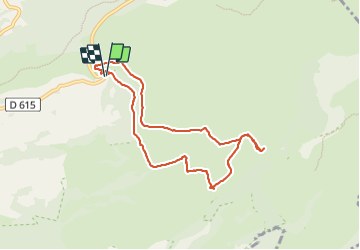

Length
8.4 km

Max alt
1374 m

Uphill gradient
200 m
Km-Effort
11 km

Min alt
1275 m

Downhill gradient
200 m
Boucle
Yes
Creation date :
2023-07-15 09:10:56.856
Updated on :
2023-07-15 12:28:38.487
3h17
Difficulty : Easy

FREE GPS app for hiking
 SityTrail
IGN / Geographical institutes
SityTrail Plus
The world is yours!
About
Trail Walking of 8.4 km to be discovered at Auvergne-Rhône-Alpes, Puy-de-Dôme, Chastreix. This trail is proposed by PMarter.
Positioning
Country:
France
Region :
Auvergne-Rhône-Alpes
Department/Province :
Puy-de-Dôme
Municipality :
Chastreix
Location:
Unknown
Start:(Dec)
Start:(UTM)
482104 ; 5040884 (31T) N.
Comments