


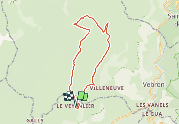
Boucle sur le Causse Méjean

piem
User

Length
15.2 km

Max alt
1244 m

Uphill gradient
391 m
Km-Effort
20 km

Min alt
1082 m

Downhill gradient
391 m
Boucle
Yes
Creation date :
2023-07-16 08:44:45.328
Updated on :
2023-07-16 09:11:03.897
4h38
Difficulty : Very difficult

FREE GPS app for hiking
 SityTrail
IGN / Geographical institutes
SityTrail Plus
The world is yours!
About
Trail Walking of 15.2 km to be discovered at Occitania, Lozère, Fraissinet-de-Fourques. This trail is proposed by piem.
Description
Boucle sur le Causse Méjean au départ du Veygalier en passant par le point culminant du causse (Mont Gargo 1247m)
Positioning
Country:
France
Region :
Occitania
Department/Province :
Lozère
Municipality :
Fraissinet-de-Fourques
Location:
Unknown
Start:(Dec)
Start:(UTM)
541896 ; 4897332 (31T) N.
Comments