


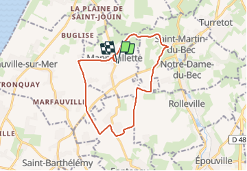
mannevillette

RoMo
User

Length
13.2 km

Max alt
107 m

Uphill gradient
125 m
Km-Effort
14.9 km

Min alt
53 m

Downhill gradient
125 m
Boucle
Yes
Creation date :
2023-07-16 06:57:54.024
Updated on :
2023-07-16 10:24:35.107
2h44
Difficulty : Difficult

FREE GPS app for hiking
 SityTrail
IGN / Geographical institutes
SityTrail Plus
The world is yours!
About
Trail Walking of 13.2 km to be discovered at Normandy, Seine-Maritime, Mannevillette. This trail is proposed by RoMo.
Description
beau circuit
Positioning
Country:
France
Region :
Normandy
Department/Province :
Seine-Maritime
Municipality :
Mannevillette
Location:
Unknown
Start:(Dec)
Start:(UTM)
296092 ; 5497469 (31U) N.
Comments