Cirque de Gavarnie

lebarça
User
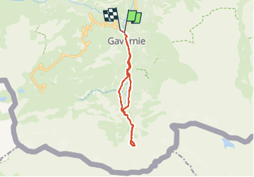

Length
11.2 km

Max alt
1871 m

Uphill gradient
519 m
Km-Effort
18.1 km

Min alt
1367 m

Downhill gradient
522 m
Boucle
Yes
Creation date :
2023-07-16 11:51:39.0
Updated on :
2024-08-14 17:02:34.091
4h39
Difficulty : Easy

FREE GPS app for hiking
 SityTrail
IGN / Geographical institutes
SityTrail Plus
The world is yours!
About
Trail Walking of 11.2 km to be discovered at Occitania, Hautespyrenees, Gavarnie-Gèdre. This trail is proposed by lebarça.
Positioning
Country:
France
Region :
Occitania
Department/Province :
Hautespyrenees
Municipality :
Gavarnie-Gèdre
Location:
Gavarnie
Start:(Dec)
Start:(UTM)
744744 ; 4735716 (30T) N.
Comments