


Descente des Canallettes à la source du Durzon

leboucherdaniel
User
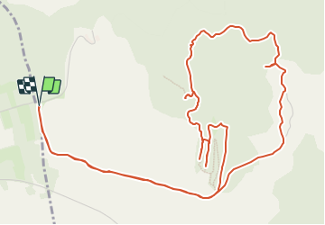

Length
8.7 km

Max alt
737 m

Uphill gradient
124 m
Km-Effort
10.3 km

Min alt
677 m

Downhill gradient
123 m
Boucle
Yes
Creation date :
2023-07-17 09:11:55.812
Updated on :
2023-07-17 09:28:34.291
2h20
Difficulty : Easy
2h20
Difficulty : Medium

FREE GPS app for hiking
 SityTrail
IGN / Geographical institutes
SityTrail Plus
The world is yours!
About
Trail On foot of 8.7 km to be discovered at Occitania, Aveyron, Nant. This trail is proposed by leboucherdaniel.
Points of interest


Positioning
Country:
France
Region :
Occitania
Department/Province :
Aveyron
Municipality :
Nant
Location:
Unknown
Start:(Dec)
Start:(UTM)
518947 ; 4869433 (31T) N.
Comments