


randonnée apremont

colomb24
User
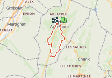

Length
10.1 km

Max alt
1012 m

Uphill gradient
270 m
Km-Effort
13.7 km

Min alt
876 m

Downhill gradient
267 m
Boucle
Yes
Creation date :
2023-07-17 06:25:38.473
Updated on :
2023-07-17 09:18:36.167
2h52
Difficulty : Difficult

FREE GPS app for hiking
 SityTrail
IGN / Geographical institutes
SityTrail Plus
The world is yours!
About
Trail Walking of 10.1 km to be discovered at Auvergne-Rhône-Alpes, Ain, Apremont. This trail is proposed by colomb24.
Description
facile
Photos


Positioning
Country:
France
Region :
Auvergne-Rhône-Alpes
Department/Province :
Ain
Municipality :
Apremont
Location:
Unknown
Start:(Dec)
Start:(UTM)
705069 ; 5120547 (31T) N.
Comments